“Pit-sawn timber was used, with 14 foot ceilings in all rooms. Weatherboard covered the exterior while the interior was lined with six inch clapboard, firmly fitted and overlapped. A wide verandah around the whole building provided protection from the hot summer sun. Large double doors served as an entrance to the bar, beneath which was a cellar. Numerous doors opened onto the verandah, giving access to hallways, bedrooms, kitchen, harness room, taproom, dining room and parlour, both 27 feet long. Six fireplaces with back to back chimneys (a common arrangement found in Cornwall) ensured heating during winter months. An illusion of coolness in summer was obtained by the use of dark stain varnish covering all interior timbers…”
Excerpt from Leila Aldercice’s book Gilgunnia, A Special Place.
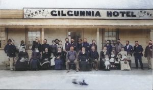
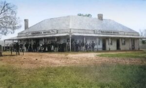
Henry and Sidwell built and established the Gilgunnia Hotel in place of the Wayside Inn. Henry was granted a publican’s licence for the new hotel at a special meeting of the Hay District Police Court in September 1873.
In 1888 The Town and Country Journal relayed a curious report from a, perhaps enterprising, Gilgunnia hotelier;
“…At Gilgunnia, Mrs. Kruge, the landlady of the Gilgunnia Hotel, said that the men when sinking the under-ground tank found A NUMBER OF RUBIES. Some of these were sold at good prices; and others were given away to friends; but no efforts appear to have been made to test their value, or to look for more…”
In 1895 an Aboriginal prospector known as ‘Jackey’ Owen discovered a quartz reef, prompting an influx of people and a settlement known as ‘New Gilgunnia’ which, within a year of the discovery, had three hotels, eight stores, four stables, two stores, sixteen slab huts, eleven log huts, 31 weatherboard huts and one iron hut. The old Gilgunnia Hotel became a homestead which survived until 1976, when it was destroyed by fire.
Gilgunnia has been in decline for over 100 years. On 30 March 1918 the Hillston Spectator and Lachlan Advertiser observed;
“…Gilgunnia presents a forlorn spectacle. Once a flourishing gold field with a population of nearly 3000 people it is now a deserted camp, and little remains except the immense mounds or dumps which stretch round almost in a circle of where the township was located. All that is left of the town is Tattersall’s Hotel, which is ably conducted by Mr Albert Hodge (who does a flourishing business with the travelling public); a deserted store, and a Chinaman’s garden…”
But for a place that exists mostly in memories, this lyrical description by Leila Aldercice is as fitting a tribute as you can find:
“I can see the village of Gilgunnia in my imagination on a hot, summer’s day. I am surprised by the soft, blue haze surrounding the two tall peaks in the background, softening the harshness and in sharp contrast to the intense hue of the sky, fierce and cutting, forcing one to seek shelter from the excessive heat but there is no natural shade left. The large trees have gone, hewn down to provide timber for rough dwelling places. Only stunted Cypress remain leaving the land itself exposed, bare and vulnerable.
I have a vision of square or rectangular log and slab huts with dehydrated, disintegrating bark roofs atop, sitting squat, brown and drab upon orange-red soil. I can feel the impact of hot, northerly winds laden with burden of dust to distribute, stinging and irritating eyes on a day of drought. …
I live there in a year of plenty when grass is green and tall, the Battery Tank brimming full of water, days warm and nights pleasantly cool with millions of stars spread about. I know of nights almost as light as day so brightly does the moon shine down…”